|
| *****SWAAG_ID***** | 686 |
| Date Entered | 24/02/2013 |
| Updated on | 24/02/2013 |
| Recorded by | Tim Laurie |
| Category | Settlement |
| Record Type | Archaeology |
| SWAAG Site | Hagg Farm |
| Site Access | Public Access Land |
| Record Date | 17/02/2013 |
| Location | Fremington Edge above West Hagg |
| Civil Parish | Reeth |
| Brit. National Grid | SE 0576 9913 |
| Altitude | 310m |
| Geology | Sloping terrace at base of Underset Limestone strata steeply dipping to the south. |
| Record Name | Fremington Edge above The Hagg. Possible house platform with stone banks and remains of later stone walled enclosures |
| Record Description | At least two levelled platforms which are possible the stances for round house structures with associated stone banks and the remains of later quarried stone faced enclosure walling.
These slight settlement remains extend along the terrace over a distance of 200m. |
| Dimensions | See photos. Not yet surveyed. |
| Additional Notes | Very slight remains and these encplatforms may or may not be contemporary with the extensive linear platform settlement at a higher levelsome 400m to the NW which has also not yet been surveyed and which will be recorded seperately. |
| Image 1 ID | 4023 Click image to enlarge |
| Image 1 Description | ossible house platform and enclosure on terrace below the Underset Limestone. | 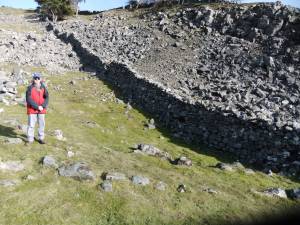 |
| Image 2 ID | 4022 Click image to enlarge |
| Image 2 Description | | 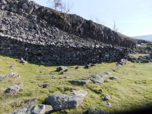 |

